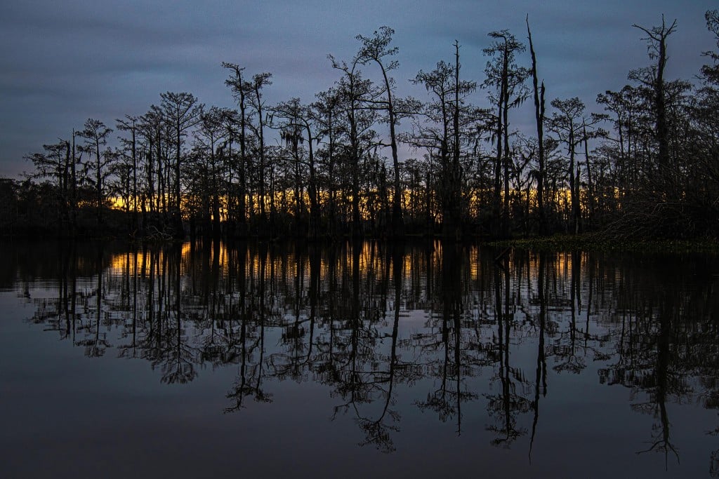
Atchafalaya Basin
The future of America’s largest river swamp is at risk, but the people working to conserve this vital ecosystem have hope for its future
Stepping from The Enterprise (“It boldly goes where no boat should go”), Bryan Piazza and Joseph Baustian enter the dry bed of a nameless bayou.
It’s winter in the Atchafalaya Basin, a season of low water and expectation. In the coming weeks, rising water will carry seeds of yellowtop, depositing them in the high ground of America’s largest river swamp. Each year, the cycle continues. For a few months, in one of those small miracles of nature, this camouflage land of greens and browns blooms golden. This landscape deserves its own Vincent van Gogh, its own Mary Oliver. In Bryan Piazza, it has the closest we may get to a resident Henry David Thoreau.
Piazza is director of freshwater and marine science for The Nature Conservancy, the global, nonprofit environmental organization whose mission is to “conserve the lands and waters on which all life depends.” He knows the science of the Basin. He also knows its rhythms. Piazza has spent the past 20 years studying both. He has also written a book — the book — on the subject: “Atchafalaya River Basin: History and Ecology of an American Wetland” (2014).
“This is my favorite time in the Basin,” Piazza says as he stops to examine the golden flowers blooming along bayou banks and in the deep woods. But all good stories tell at least two stories. Begin with a landscape that in its golden brilliance rivals the rolling springtime rapeseed in France’s Loire Valley. In that beauty, Piazza also discerns something else. From the yellowtop, he has learned to read the Atchafalaya River’s temperament. To see these flowers in bloom, he knows, means the river is already rising. The Atchafalaya is North America’s fifth largest river, by discharge. In the highwater year of 2011, it stood second only to the Mississippi. Here, in these waters, Piazza seeks his answers.
With Joseph Baustian, a wetland ecologist for The Nature Conservancy, Piazza continues along the dry bayou bed. They move in the direction that water once regularly flowed. Now it passes through here only in highwater years. That’s because the Basin, like much of south Louisiana, is sinking. After the 1927 Mississippi River flood, the U.S. Congress passed the Flood Control Act of 1928. The Atchafalaya Basin became an official floodway. The man-made levees built to combat future floods permanently altered the distribution of floodwater patterns in the region. Those levees that keep much of south Louisiana inhabitable also exacerbate subsidence.
Baustian pauses, allowing his gaze to follow the slight curve of the bayou bed. It’s as wide as single-lane dirt road, as dry as one after weeks without rain. “You don’t want water to linger,” he says, offering elegant simplicity to what can sometimes seem like one of the world’s more complex plumbing systems. That’s because we’re talking, here, about the largest wetland and swamp in the United States. It’s also a threatened place, one of extreme importance to the region.
Baustian nods as his gaze follows the bayou until a slight bend, 50 yards ahead. “You want water to flow into the Gulf as quickly as possible,” he says. That description (simple, yes, simplistic, no) provides the kernel of what he and Piazza are working to address. The Atchafalaya River has been dredged and straightened to hold more water without spreading that water over the floodplain, as it has throughout history. Today, this means that water from nearly half of the continental U.S. continues to reach the Basin, as it always has. The difference, however, is that it now often moves through the system of waterways without ever reaching the swamp.
“Look at a map,” says Baustian, “and you will see that the Basin looks like three tongs of a fork.” Around those tongs intersect, much like twirled angel hair pasta, hundreds of man-made canals. These canals, many of them dredged in the 1960s, obstruct the north-to-south flow of water. In some cases, the canals have changed the direction of waterflow. Now, there are bayous and smaller waterways — what Piazza calls trenasses — through which water flows backwards. Another problem is that these man-made canals continue to widen after they are dredged, causing the swamp to erode from within.
Baustian and Piazza step around the yellowtop, careful not to disturb any of the knee-high flowers. In this high ground, they’re searching for more hints, signs from the here and now, that will inform them about the future. At the sight of two cypress seedlings, Piazza grows animated. The first is scraggly, two feet tall. Next to it rises another seedling twice its size. Beside each, he stops to lay his hands on the twig-like branches before offering a verdict: “This small one won’t make it, but the bigger one has a chance.”
Baustian explains the problem: “It’s not that the seeds don’t sprout. It is that the seedlings normally can’t grow tall enough in one year before the next flood comes and covers them up.” Even if completely under water, cypress seedlings can survive for several weeks. Longer periods under water mean that the tree has not been able to photosynthesize and grow, and current Basin conditions mean that the back-swamp habitat is flooded — and stagnant — for months at a time.
At a rifle’s report, Piazza and Baustian turn from the seedlings. Moments later, beyond the thick tupelo that crowd the banks, a glimpse into Bayou Sorrel reveals a crawfish boat with traps piled high. On board, two fishermen inspect water levels to gauge whether it’s time to set traps. There’s no calendar season for crawfishing in the wild. Instead, this work is entirely dependent upon water levels. Highwater years mean greater crawfish production, and Louisiana’s more than 1,300 crawfish farmers flood and drain ponds in order to mimic the natural cycle of the Atchafalaya Basin. Those who work in the wild, contributing to Louisiana’s $300-million-dollar annual industry, rely on the rhythms of nature, like these two who are out inspecting today. They could have saved time, and gas, if they had called Piazza and Baustian.
“Everything here is connected,” Piazza says as the crawfishermen’s boat sputters down the bayou.
Plants and trees, wildlife and water: In them, Piazza, Baustian, and other research fellows at The Nature Conservancy seek clues to comprehend North America’s largest floodplain swamp. The Atchafalaya Basin’s geographical size, much like its ecological, economic, and cultural importance, is nearly unfathomable. At almost one million acres, it’s four-fifths as large as the Grand Canyon. It’s larger than the state of Rhode Island, larger than Yosemite National Park. The Atchafalaya Heritage Area runs through fourteen of Louisiana’s 64 parishes, beginning at Concordia and spreading south to St. Mary. At its geographical heart in Iberville Parish is the newest addition to the Nature Conservancy’s portfolio, a 5,000-acre preserve near the town of Bayou Sorrel. Conserving these lands and waters means restoring health to a region of deep woods and fertile marshes, a landscape of broad economic potential and arresting beauty where nearly 300 species of wildlife, nearly 100 aquatic species, and a rich diversity of native plants all thrive — or at least where they have had the chance to do so throughout history.
Strains on the environment, many of them man-made, mean that the health of the Basin now suffers. In a place that pulses with waterways — among them bayous, swamps and backwater lakes that, all told, comprise 30 percent of its expanse — it’s no surprise that everything here begins and ends with water.
“The plumbing is broken,” Piazza says. “What we know is that water isn’t getting into the swamp.” For that reason, he and Baustian focus much of their energy on the water itself. In their search to understand what a healthy Basin looks like, they examine scientific data collected during the past one hundred years. The degraded water conditions in today’s Basin show them that everything suffers, from forest health to wildlife habitat. Much of this deterioration stems from the past five decades of man’s interference.
“The life of every river sings its own song, but in most the song is long since marred by the discords of misuse,” wrote Aldo Leopold in “A Sand County Almanac” (1949). Despite decades of misuse here, Piazza and Baustian are confident that change remains possible. Start with restoring the water quality, they say, and you will witness a revitalization in the overall health of the Basin.
“If we can get the Basin to regenerate, it makes healthy crawfish,” Piazza says. “It makes healthy trees. If we can get one right, we get them all right.”
Getting them right here, in this 5,000-acre section, is crucial. In 2019, on the eve of the global pandemic, the Nature Conservancy opened its floating Atchafalaya Conservation Center (ACC). Built on two barges, each containing an 800-square-foot building, with space between, the ACC sleeps 12 comfortably, more if necessary, and contains a conference room and kitchen. At both ends, screened-in porches offer views of Bayou Sorrel and Little Tensas Bayou, where, on this day, several commercial fishermen pass on their way to check hoop nets for catfish and buffalo. On these waterways and others throughout the Basin, researchers from LSU, Nicholls State, the universities of Louisiana at Lafayette, Southern Illinois, Delaware, Oklahoma and Southern Mississippi have generated seven theses, all since 2016, on topics that include waterflow, nitrogen deposition, and the health of wild crawfish.
“The idea for the floating center was to have a place where people can come to talk about the Basin and to learn together,” Piazza says.
Besides researchers, the ACC also offers a place, one central to The Nature Conservancy’s mission, for the Basin’s residents. Locals built and designed the floating structure. From one porch, you can look across Little Tensas Bayou and see, on the opposite bank, the house of Orry Mendoza, the carpenter who built the structures that sit on the floating barges. The latter were custom built by Bayou Fabricators & Marine Works in Plaquemine. Locals maintain the grounds. Commercial fishermen stop by to share news about what they see inside the combined 449 miles of federal levees in the Basin — all told, three miles less than a one way-drive from Baton Rouge to Birmingham. “Locals, and anyone with a stake in the Basin, now have a place to come,” Piazza says of the ACC.
Those who depend on the Basin for their livelihoods have no difficulty understanding the importance of what’s at stake here. Others may know of the Basin only as a rumor. It’s out there, a wild place somewhere in the Louisiana hinterland, our very own Amazonia of deep and mysterious swamp, Hollywood’s double, in the original “Tarzan of the Apes” (1918), for the African jungle. But to sit comfortably in a living room in Lafayette or Baton Rouge or New Orleans also means to have a stake in the Basin.
Stop and think about the daily efforts at the Old River Control Structure Complex, which maintains the distribution of waterflow between the Atchafalaya and Mississippi rivers northeast of Simmesport, and you will quickly comprehend the precariousness of life in south Louisiana. If you live in that region, you will also find yourself grateful for clever engineering. By 1951, after a succession of multiple flood years, the Army Corps of Engineers knew that it needed to prevent the Atchafalaya — long river, in its original Choctaw — from overtaking its even longer source if Baton Rouge and New Orleans, along with much of south Louisiana, were to continue to exist as anything other than places of legend. By 1953, conditions revealed that the Mississippi River could alter its course by 1990. To combat this takeover, the Army Corps of Engineers began work on the Old River Control Structure, which it completed in 1963. There, in Concordia Parish, the Auxiliary Structure divides waterflow, allowing the Atchafalaya to acquire 30 percent of the Mississippi River. Glance at a map of the area, and you will see the Mississippi’s general southward path begin to turn slightly southwest at Vicksburg before it shifts to its current south-to-southeastward journey.
That shift is necessary for life as south Louisianans know it. Throughout history, North America’s largest river has sought the shortest and most efficient path to the Gulf of Mexico. Its desire to offer itself to the Atchafalaya, thereby combining forces, would allow the larger river to reach the Gulf in 142 miles as opposed to the 315 miles of its present course. These rivers, soulmates in the cosmos of waterways, have been kept apart because man’s desires overrule nature’s impulse. Thus, in “The Control of Nature” (1989), John McPhee provides a more current connotation of Atchafalaya: “The word will now come to mind more or less in echo of any struggle against natural forces — heroic or venal, rash or well advised — when human beings conscript themselves to fight against the earth, to take what is not given, to rout the destroying enemy, to surround the base of Mt. Olympus demanding and expecting the surrender of the gods.”
Inhabitants of south Louisiana live, always, with water or its possibility at the back of the mind: rivers, bayous, swamps, rain, flood threats. Add to that the annual anxiety before and during hurricane season. The importance of Baustian and Piazza’s work becomes even more significant when you consider that the Mississippi has reached highwater levels in five of the past 10 years. In one of those — from Dec. 28, 2018, through Aug. 10, 2019 — the Mississippi reached its longest flood year on record.
“The system is designed as a pipeline to pump water through here for flow control, through a network of canals and bayous,” Piazza says. The dredging of oil canals left mounds of earth on the banks. Now, these spoil banks rise — some like small bluffs, others like burial mounds — five, 10, as much as 20 feet above water level.
“The design, all of the cuttings of oil canals, now means that it takes higher river floods to get water into the swamp,” Piazza says. “This means more water is necessary, but that water rarely comes — except in those vast flood years when the Bonnet Carré and Morganza spillways are opened. These record river years pose questions: Is the Mississippi River changing? Or is this episodic?”
And so here, in this dry bayou bed, Baustian and Piazza prepare to make their stand. If a healthy Basin begins with healthy water, both know that the best place to begin is with the most obvious problem: Water now fails to spread through the swamp on its journey to the Gulf of Mexico. This causes stagnation, which, in turn, has created a dead zone. It’s similar in comparative destruction to the dead zone in the Gulf of Mexico, where oxygen levels have dropped “basically to zero,” Piazza says. “This places stress on trees. If trees don’t grow, they don’t take up carbon. It means smaller crawfish and extends to all seafood in the Basin, which is a key area for commercial and sport fishermen.”
Preventing that stagnation requires reconfiguring the plumbing, and to do so, Baustian and Piazza focus on this nameless bayou, a one-time link for water flowing from Bayou Sorrel into the back swamp. This is merely one of dozens of historical waterways that, due to the dredging of canals, no longer moves water regularly through the Basin. The data that they have collected reveals that as much as 90 days of water per year in this bayou alone will be enough to improve conditions. Even as few as 30 days would create a significant change. The 90-day scenario, they say, will allow enough water to pass through the Basin to remove the equivalent of 54,000 14-pound bags worth of fertilizer and all of the pesticides that flow into the Basin from Midwestern farmland drainage.
“One of our students converted the amount of nitrogen that the swamp could potentially remove through a microbial process called denitrification,” Baustian says. This research shows up to a 20 percent growth spurt in trees when they are connected to the path of flowing water.
This project is one Piazza and Baustian have been waiting to commence — waiting, because their application lingers in labyrinthine bureaucracy. Shortly after filing their permit application to commence work, their state agency contact moved from the Department of Natural Resources. The Coastal Protection and Restoration Authority is now overseeing the work and has filed the application with the Army Corps of Engineers. Still, they’re hopeful that work will start before the end of the year. When it does, they will transport a small excavator down Bayou Sorrel on a barge. With it, they will shave three feet from the bottom of the bayou bed. Such an adjustment will allow water to flow regularly from Bayou Sorrel into this dry bayou, which will transport it into the back swamp even in non-record-setting flood years. That water will fertilize trees. It will regenerate wildlife. It will remove nitrates that contribute to the dead zone. It will provide habitat for healthier crawfish.
All of that here, in this one place, this speck within the vastness of the Atchafalaya River Basin. It’s a place of significant promise, as Baustian and Piazza’s work reveals, one that has the potential to reverse decades of misuse. For now, it’s still a place without a name. “I think that Bryan Bayou has a nice ring to it,” Piazza says. For a few seconds, he and Baustian laugh. Then they start moving through the dry bed, glancing upon the yellowtop as they return to The Enterprise, which will take them to the floating ACC so that they can get back to work.