Drastic Measures
The Louisiana coast is many things to many people.
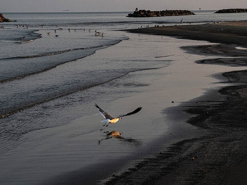
Home. A livelihood. Vacation. Beauty. A breath of fresh air. With over 7,000 miles of squiggly coastline — more than any other U.S. state besides Alaska and Florida — Louisiana waterways are a paradise to not only sportsmen, but also businessmen, nature-lovers and, of course, nature itself. Louisiana wetlands are home to the iconic American alligator, several species of snapping turtles, brown pelicans, great blue herons, great egret, osprey, a range of migratory songbirds, as well as coyotes, muskrat, bobcats and even the elusive black bear.
But the hard truth, for us and all of these critters, is that this coastline is vanishing. Since the 1930s, the state has lost an estimated 2,000 square miles of coastal marsh — the size of the state of Delaware — which has caused myriad problems ranging from what to do about ownership and taxes on that square mileage to how to manage shrinking resources for fisherman whose livelihoods depend on them.
“One of the things you might have heard over the years is that Louisiana loses a football field of wetlands every hour,” said Alisha Renfro, staff scientist at the National Wildlife Federation. “Now it’s about every hundred minutes that we lose a football field of wetland.”
That slight slowing is thanks in part to billions of dollars of state restoration programs, relatively mild hurricane activity in recent years and fewer wetlands left to disappear. But it doesn’t mean we’re in the clear.

In this photo provided by the Coastal Protection and Restoration Authority, Louisiana Gov. John Bel Edwards sticking a large pin in a mural of Louisiana’s coast, in Baton Rouge, La., Wednesday, Feb. 12, 2020, to show the location of the Maurepas Swamp. (Coastal Protection and Restoration Authority via AP)
THE BIRDFOOT
The natural state of the Mississippi River Delta in Louisiana is one of regular flooding. Historically, several times a year in response to snow melt or rain to the north or storm surges from the south, the river would swell beyond its banks, fanning out in a thin layer over the surrounding delta and carrying fine sediment out of the river channel with it. This sediment built land.
In 1927, a devastating flood gave way to the Flood Control Act of 1928. Miles of levees were built to prevent the Mississippi River from overtopping its banks. As a result, it no longer fans out over the delta and it no longer brings sediment to the marsh plants that root themselves in it. The new, channelized shape of the river delta is referred to as a “birdfoot” delta because the levees guiding the river constrict it to one path through the delta, a bird leg, which then splits into three talon-like channels as it reaches the Gulf of Mexico, which resemble a bird’s foot.
At Louisiana State University, scientists have built the birdfoot delta indoors, in a space the size of two basketball courts. With one foot of the model equal to one mile of the actual river, it is an exact replica of the Mississippi River from Donaldsonville south to the Gulf of Mexico. It has levees and plastic sediment particles and it can match the scaled flow of the river at any time through history.
“We know, for example, that the average moving velocity of water moving down our model river is one twentieth the average velocity of water moving down the actual river,” said Clint Willson, director of the Center for River Studies. “If you tell me today the river is moving at one million cubic feet per second, we know exactly how much water to put into our model river to replicate that at model scale.”
Willson runs experiments using the river model to determine how changes to river flow and sediment load might build land or leave marshes to erode away. Next he intends to run a simulation of the Mid-Barataria River Diversion project, which will divert freshwater and sediment from the Mississippi River, through a series of channels just north of Ironton out into the Barataria Basin, which has been depleted of sediment since the levees were built. The experiment will run for fifty years in model time — about 50 hours in real time — and tell his team how much land, and where, the project is likely to produce.
But just one project won’t do the trick, Willson says. Addressing the threats facing the coast will require many different kinds of projects, implemented by many generations of Louisianans.
“We [the Center for River Studies] are also educating and producing students and graduates who have a better appreciation for our coast and the relationship between engineering and ecosystems,” said Willson. “We want to be a creative and innovative hub, helping educate the next generation of scientists and engineers who are going to be working on these problems.”

THE PROBLEMS
The task for the next generation of Louisianans is complex. Scientists say that the situation at the coast is an interplay of sea level rise and subsidence (sinking) with coastal erosion from storms, oil and gas development and the retreat of marsh plants.
The marsh plant Roseau cane, for example, makes up much of the front-line of defense against increasingly severe tropical storms. It’s one of the state’s most hardy and widespread wetland plants, and it is currently being attacked by an invasive scale insect that, as of 2017, had decimated 100,000 acres of Roseau cane in Plaquemines Parish alone. Scientists aren’t yet sure how to combat the scale insect, and it might not be the only culprit behind the reed’s retreat anyway: toxins in the soil (as from old oil spills), rising sea levels and increased salinity due to freshwater diversions may also be causing wetland plants to die back or fail to take root.
“The estuaries are sinking and no longer recruiting young trees because they’re too deep,” said David Muth, director of the Gulf Restoration Program at the National Wildlife Federation.
Sea rise is a result of thermal expansion of the ocean as average global temperatures increase, and glacier melt causing more of the world’s water to be in the sea as liquid rather than bobbing at its surface in ice form. Saltwater intrusion is also human accelerated, in two ways: diverting fresh river water from where it once flowed allows salt water to advance, and digging canals for oil and gas rigs or shipping vessels opens up passages for saltwater, too, to travel inland, disrupting plant and fish reproduction in near-shore estuary waters.
“What you end up with [by dredging] is a canal that used to be wetland, and what was there piled up on either side of it, and that’s not wetland either,” said Denise Reed, a coastal geomorphologist at the University of New Orleans and 2020 Louisiana Life Louisianian of the Year, who has worked in Louisiana coastal wetlands for 35 years. “So, you’ve immediately contributed to land loss.”
Reed worries that if the combination of coastal erosion, sea rise and subsidence continues, “we could lose a whole lot more land.” She is also concerned that “we don’t really have any technology for reversing subsidence.” A 2017 report by the Geological Society of America found that, on average, coastal Louisiana is currently sinking by about 9 millimeters, or nearly 4 inches, per year.
The rising sea, sinking soil and retreating marsh leave Louisiana vulnerable to a host of changes, and less of a good host to wildlife. Rising saltwater closer to shore is changing what can live there. And less life out in the marshland means less of a barrier between humans and hurricanes.
“The money that comes to Louisiana for coastal restoration has a lot of strings attached to it. Funding is also based on oil and gas prices, so when that industry goes down, this funding goes down.”

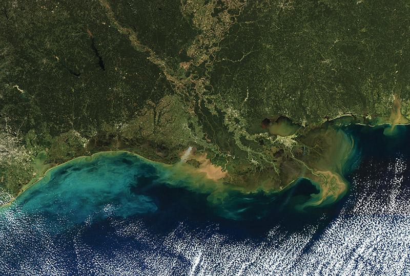
Oil production facilities are showing from the air in the Barataria Bay region of Louisiana, Oct. 22, 2004. State and federal officials are touring the coast of Louisiana to learn more about the problems Louisiana faces with coastal erosion. (AP Photo/Bill Haber)
THE BLAME
The coastal system worked beautifully before humans intervened with dredging and levees and contributions to climate change, said Muth. While diverting the Mississippi and the Atchafalaya Rivers with a complex system of levees and dams to prevent flooding in settled areas temporarily saved inland homes, it created the main cause of our vanishing coast.
“The whole [delta] system is built on a steady annual influx of sediment,” said Muth. “None of the sand that reaches the Gulf now is in shallow enough water to be recruited [into land]. The whole system worked beautifully for 140 million years until we started tinkering with it 300 years ago. So, we have to fix all that.”
Fixing that, though, puts some industries under water. The answer is not quite as simple as just putting freshwater and sediment back where they were, because now there are communities and fishing practices and businesses in the way.
Development by the oil and gas industry has also been implicated in worsening saltwater intrusion, the degradation of marsh ecosystems and the natural process of subsidence. A 2015 report by the New Orleans Geological Society named oil and gas extraction as one of the primary causes of subsidence, since removing liquid from underneath the surface causes settling of the sediment to a lower level.
Solutions to this problem are muddied by the fact that, according to a 2018 Grow Louisiana Coalition report, the oil and gas industry employs nearly 45,000 Louisianans. Since the Deepwater Horizon oil spill 10 years ago and the resulting $20.8 billion environmental settlement, the oil and gas industry is also a major source of funding for some coastal restoration projects that otherwise might not be possible.
“The money that comes to Louisiana for coastal restoration has a lot of strings attached to it,” said Simone Maloz, Executive Director of Restore or Retreat. “Funding is also based on oil and gas prices, so when that industry goes down, this funding goes down.”
THE SOLUTION
There are no easy answers for Louisiana. But there are a few billion dollars earmarked for finding the best ones. Since the devastation of Hurricane Katrina, Louisiana has developed a new coastal master plan every five or six years to manage coastal restoration and hurricane surge risk reduction. The most recent plan, released in 2017, has a $50 billion budget: $25 billion for restoration and $25 billion for risk reduction. The plan outlines proposed state projects that include diversions of freshwater and sediment from rivers to build wetlands, shoreline protection, ridge restoration, marsh creation, bank stabilization, oyster barrier reef creation and barrier island restoration, among others.
“The opportunity we have right now with the funding that’s come through is to invest in some of these large-scale marsh creation projects and do river diversion to help offset loss,” said Renfro.
According to Muth, the best way to restore the coast is to divert sediment, strategically, from the state’s two major rivers — the Mississippi and Atchafalaya — into the wetland-dominated deltas that were created by floods before we built up the levees to stop them. But that will mean injecting freshwater into some ecosystems that have since adapted to saltier conditions.
“Many species that do best in the saltier end, like oysters, have moved steadily inland up the estuaries and it’s going to be extremely disruptive for the industries built around them to put freshwater back into those estuaries. The pushback is completely understandable,” Muth said. “Of course, the alternative is to continue the current processes, which is a zero-sum game. There won’t be any of those species to worry about and, of course, there won’t be any humans around anyway.”
Meanwhile sea level rise, which is expected to affect 41,000 homes, 99,000 people and $36 million in annual property tax revenue in Louisiana by 2045, threatens to undermine every coastal rehabilitation project. The only known solution? Cutting global emissions to slow climate change.
“As we do the things we need to do to protect ourselves, it’s important that we step in to help those who might be affected in other ways and do what we can to help them.”
THE PUSHBACK
“Certainly, oysters are a huge part of the cultural identity of Louisiana,” said Brian Callam, director of the Louisiana Sea Grant Oyster Research Lab. “You can’t walk through New Orleans without passing a restaurant trying to sell you a dozen charbroiled oysters.”
Louisiana is likely to remain the dominant oyster-producing state for a long time, Callam says. “But we’ve seen downward trends on the public oyster reefs where there’s not as many juvenile oysters available for farmers to transplant back to their leases.”
The oyster industry is just one of the entities that will suffer when river and sediment diversion initiatives return fresh water from the Mississippi and Atchafalaya Rivers to parts of the delta. Other fishing industries, like shrimping, are likely to be hit even harder.
Callam says the fishermen he works with are oftentimes fourth and fifth generation water workers who have adapted their practices to the increased salinity of the coastline. They are struggling to know if their way of life is stable.
“It’s hard to plan your business year to year, or five years or 10 years from now, when you have no idea what projects are going to be in place and how those are going to change the coast,” he said.
But it is all part of a necessary and natural process, and the alternatives are much worse, says Muth.
“[Sediment diversion] doesn’t mean that those species are going to disappear, they’re just going to move,” he said. “There’s always going to be a zone where oysters can grow.”

In this March 29, 2018 photo, Rudy Simoneaux, above, engineer manager for the Louisiana Coastal Protection and Restoration Authority, and Joseph McClatchy, coastal resources program specialist, walk on a replica of the lower Mississippi River in Baton Rouge, La. The model will help experts study the river and how sediment can be used from it to fight coastal erosion. (AP Photo/Gerald Herbert)
THE FUTURE
The outlook is not the same for everyone. Tribal communities on the coast, many unrecognized by state and federal agencies, are fighting today against rising seas and raging storms. Their homes and way of life are already threatened by delayed action on coastal goals.
“As we do the things we need to do to protect ourselves, it’s important that we step in to help those who might be affected in other ways and do what we can to help them,” reminds Steve Cochran of the Environmental Defense Fund.
Local scientists, though, are optimistic about the state’s restoration and diversion plans.
“Since 2012, we’ve been using a pretty systematic, scientific approach to decide what projects [the state] should spend money on to restore the coast,” said Reed. “We have been, I think, remarkably successful at developing predictive models that support this process.”
Rudy Simoneaux, engineering division chief at the Coastal Restoration and Protection Authority of Louisiana, is likewise optimistic about what we can learn from both computer models and the Center for River Studies’ 120-foot high-density foam river model.
“It’s another tool in our toolbox that we’re using to better understand the Mississippi River and how we can use it to rebuild and sustain our coasts,” Simoneaux said, referring to the physical river model. “When you look at removing a part of the Mississippi River levee and actually flowing water and sediment down a man-made channel, that is a mega project. But if we can show our success, perhaps the federal government will think it’s worth contributing.”
Simoneaux says he hopes more funds might pour in from federal pots of money once the state can demonstrate success with current projects. Right now, even with the Deepwater Horizon settlement money, the state is shy of its $50 billion for Coastal Master Plan projects. But money, and effort, is starting to flow.
“Over a billion dollars over the next couple years will be spent on coastal construction alone,” said Maloz. “We’re really starting to turn the corner from planning to implementation.”
These efforts won’t be enough without the global community also slowing the effects of climate change to help counteract sea level rise and the decline of marsh habitat. But for now, it’s a good start.
“There’s still a lot of work left to do,” said Simoneaux. “But I am optimistic that certain parts of our coast will be sustained through the projects we have planned.”