People of the Mounds
y first impression of the massive ancient earthworks at Poverty Point is not a good one.
I’m driving on Highway 577 east of Epps in Northeast Louisiana and don’t realize I’ve just driven past the site’s six curved ridges until I look at a diagram later. The highway plows right through the rings, but they’ve been so worn down by farming and natural erosion through the millennia that what must once have been an impressive sight now (to the untrained eye, anyway) appears to be little more than an empty field.
But when I get a chance to see the rings and the mounds up close and learn about their construction, I quickly change my mind.
—
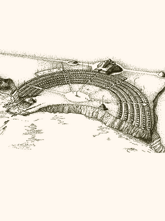
Poverty Point National Monument consists of six rings and six mounds — some of the largest prehistoric earthworks on this continent. They’re dated between 1650 B.C. and 700 B.C. and stretch more than 400 acres. The rings form a semicircle that opens toward what is now Bayou Macon. Five aisles cutting through the rings divide them into six sections.
Of the six mounds on the site, two lie within the rings’ enclosure, three run in a straight north-south line at the spine of the rings, and another mound sits well to the north. Inside the rings is a vast empty field, occupying about 37 acres, where the visitors’ center and parking lot now sit. It’s here that I join interpretive ranger Cleon Crockett for a tram tour.
—
The tour starts at the visitors’ center, at the edge of the bluff that overlooks Bayou Macon. We head first across the large plaza. “We believe the plaza was a centralized meeting place for all their social activities such as trading and feasting and playing games,” Crockett, my mustachioed tour guide, says in a casual voice that belies his quick recall of facts, dates and numbers. “But the thing about it is they probably didn’t have time to play many games because they moved so much dirt.”
We make our way to Dunbar Mound, or Mound C, located just inside the rings on the north end of the plaza. It’s the oldest mound in the park and the only one that shows evidence of habitation, possibly by a person of authority.
The early American Indians who created Poverty Point did, in fact, move a lot of dirt. It’s estimated that, before erosion and farming took their toll, the total volume of dirt in the mounds and the rings was somewhere around 870,000 to 1 million cubic yards.
As Crockett and I continue on the paved path that bisects the rings, I start to get a sense of how massive this place is and what an undertaking it must have been to create it.
“Now these ridges would have been 10 to 12 feet high when they were first built,” he says as we pass the first of the rings. Today, though, they’re nearly undetectable. “They’ve suffered over 100 years of farming and over 3,000 years of erosion, so that’s why they’re as flat as they are.” In the 1830s, the land was part of the Poverty Point plantation run by Philip and Sarah Guier.
The park lets the grass grow taller on the rings so they’re slightly easier to visualize. It takes some imagination, but I can tell they’re massive. If placed end to end, they’d be 7.5 miles long. Evidence of post holes and fire pits on the rings suggests the people who occupied Poverty Point built their dome-shaped homes on them. There’s enough space for 600 to 800 huts that housed around 1,200 to 4,000 people.
Mound A, the Bird Mound, comes into view halfway through the tour. It’s a massive structure thought to be built in the shape of a bird in flight. At a height of 70 feet, it’s the second-tallest American Indian mound in the U.S. Its wingspan stretches 640 feet, and from head to tail, it measures 710 feet. That’s large enough to hold the baseball field at Fenway Park — and then some.
“There’s over 300,000 cubic yards of dirt in this mound,” Crockett explains as we pass the mound. “That’s a little more than 17,000 dump trucks. And we know they didn’t have dump trucks back then.”
Indeed they didn’t. The ancient people who built these incredible structures laid them out with expert precision and symmetry and moved massive quantities of earth with baskets constructed of cane. I imagine carrying the equivalent of a 5-gallon paint bucket of soil on my back over and over and over.
Now I’m impressed.
—
For help making sense of the significance of Poverty Point to its occupants and understanding who they were and how they might have lived, I turn to Ray Berthelot, chief of Interpretive Services at the Louisiana Office of State Parks, and Dennis LaBatt, historic site manager at Poverty Point.
Theories abound on why Poverty Point exists. There are the less-scientific postulations that suggest the Bird Mound was built by extraterrestrials or by the people of Atlantis after their city was destroyed.
Archaeologists’ interpretations have evolved over the years. The community credits Jon L. Gibson, a pre-eminent Poverty Point historian, with the most widely accepted theory. Gibson suggests the earthworks are essentially a metaphor for the Poverty Point people’s creation story and thinks they may have been designed as protection from evil spirits.
The Poverty Point people may have seen the source of nightfall and darkness, the west, as the direction from which evil originates. With that in mind, they placed the large Bird Mound, which faces west, and the rings, which curve toward the west, in defensive positions. Perhaps they built Poverty Point as both a way of honoring the spirits of the cosmos and summoning their protection.
“There is also a recent theory that attempts to explain the layout of Poverty Point as a replica of a portion
of the night sky –– say, the Pleiades,” says Berthelot.
“Many sites, both stone or earth, throughout the world seem to mimic the cosmos,” LaBatt adds. In Poverty Point’s case, this certainly makes sense given the site’s grand scale.
“Because there is so much that we have yet to learn about Poverty Point, there is no end to the theories explaining the whys of the site,” says Berthelot. “It has intrigued researchers from the beginning and will continue to do so in the future.”
Archaeologists are active at Poverty Point, studying several different facets of the site. Anthony Ortmann, an assistant professor in the Geosciences Department at Murray State University, is currently “studying the functions of the mounds and how they interacted with each other so they can explore ideas of how the site was being operated,” LaBatt says.
“There has also been recent work done at the site, using ground- penetrating radar, which has identified several circles in the plaza that might indicate the post hole remains of structures,” Berthelot adds.
Though archaeologists have been studying Poverty Point for a century, they’ve hardly scratched the surface.
“[Only] .03 of a single percent has been examined to date, leaving a whopping 99.7 to go,” LaBatt says. “The research possibilities at Poverty Point are endless.”
The massive quantity of materials found at the site is still being examined, too. The artifacts found at Poverty Point were mostly discarded as trash and include various stone tools, projectile points, ornaments, beads, cooking balls and animal figures. Because stone does not naturally exist at Poverty Point, archaeologists have learned the culture had an extensive trade network that stretched as far as 1,400 miles away.
The objects provide clues about the lifestyle and beliefs of this culture. The majority of the artifacts were cooking objects (called Poverty Point objects. or PPOs) made of loess, which they rolled and squeezed, often leaving the imprint of the maker’s fingers and hand. There are several varieties of shapes of the PPOs, which were heated in a fire and then transferred into a pit to cook food. Projectile points and stone gorgets were probably used in atlatls, spear-throwing tools similar to present-day Chuckit! toys dog owners use to launch tennis balls to their pets. Stone plummets that resemble modern fishing sinkers were probably used on fish nets.
Archaeologists use these artifacts — their designs, stone types and radiocarbon dates — to define cultures at large.
“Culture would be defined as trait-sharing between peoples that give them an identification that can cover a large area involving possibly many tribes,” LaBatt explains.
In Poverty Point’s case, the culture existed between around 1730 B.C.
and 1350 B.C. and probably spread over a swath of Louisiana, Mississippi and Arkansas.
Although the people of the Poverty Point culture were hunter-gatherers, there’s evidence that those living at the Poverty Point site itself were sedentary year-round. The area would have had abundant resources, so it wasn’t necessary for the occupants to travel far or stay on the move to find food. And the people were likely hard at work building the mounds for much of the year.
—
Louisiana is rich in mound history. The state has the oldest mounds in North America, which were built in 4000 B.C., predating the first Egyptian pyramids by 1,350 years and Stonehenge by 1,500 years. Louisiana boasts some 700 mound sites attributed to various cultures that lived throughout the state, though most are concentrated in Northeast and Central Louisiana. There are so many clustered in the northeastern part of the state that Louisiana’s Department of Archaeology has created a driving trail guide of 39 sites. Although each has a historical marker, many are on private property — some with homes built on top of them.
The people who built mounds throughout eastern North America were the ancestors of familiar tribe names such as Creek, Choctaw and Natchez. They built mounds for a variety of reasons, ranging from ceremonial to burial, but the reasons aren’t always clear.
“We can describe how the mounds were used, in most instances, but what was the spark that ignited man to say, ‘We’re going to build a mound,’ is still an unanswered question,” Berthelot says. “It’s been speculated that, much like the pyramids in Egypt or in the Americas, there is a fascination with height and immensity going on, a desire to get closer to the heavens, so to speak, or they could represent a much more down-to-earth purpose, such as getting out of a flood plain or for defense. Combine religion, culture and practicality, and I think that you are somewhere near the answer, but we don’t know for sure. It’s these types of questions that are so exciting, where science and storytelling can merge, at least until we have more information to go on.”
One of the oldest and best-known mound sites in Louisiana consists of the two 20-foot-tall mounds on LSU’s campus in Baton Rouge. These mounds date to 3000 B.C. and recently drew controversy when LSU officials announced they’d fence the mounds off during home games to prevent tailgaters from potentially damaging them.
Dating to around the same time as the LSU mounds is the site at Watson Brake in northeastern Louisiana. There, 11 mounds connected by a ridge form an oval. At the Marksville State Historic Site in Central Louisiana, a 1,500-year-old site consists of a semicircular earthwork enclosing six mounds. At least one shows evidence of use as a burial site, and the site as a whole is thought to reflect important cosmological markers.
Two miles south of Poverty Point is the Lower Jackson Mound, which dates to 3955 to 3655 B.C. Although it’s much older than the Poverty Point mounds, researchers think the Poverty Point people may have incorporated Lower Jackson Mound into their site because it sits on the north-south axis that connects the three mounds outside the rings. Lower Jackson Mound is on private property, but it’s visible from Highway 134 leading to Poverty Point.
Not all mounds have been protected as well as Poverty Point. Modern Louisianians had a tendency to view mounds as an excellent source of fill for road construction, and many mounds have been destroyed by farming.
Where the town of Jonesville now sits, in Central Louisiana, was once a collection of mounds enclosed by an L-shaped earthwork. One of those, called the Great Mound, stood some 80 feet high — higher even than Poverty Point’s Bird Mound. It consisted of three tiers, with the top tier forming a steep cone, so it probably resembled a pyramid. The writer William Least Heat-Moon called it “the Empire State Building of prehistoric America.”
Archaeologists have pointed out that the building of the Great Mound was an engineering feat similar to the construction of the pyramids in Egypt.
The Great Mound’s destruction began during the Civil War, when soldiers dug a trench in the top from which to fire at enemies. Following the end of the war, Jonesville founders built the town directly over several of the mounds, thus leveling them. Finally, in 1931, the state used the remainder of the Great Mound to build an approach ramp for a bridge across the Black River. The bridge was demolished for a newer version last year, and a group formed to reclaim the fill and use it to build a replica of the Great Mound.
—
Though Poverty Point is now protected from human meddling, several natural threats still loom.
Gullies have formed in several places, cutting into the earth from the surrounding bayous. The park has installed drains and built small levees to combat the gullies’ damage, but it’s a tough fight.
“We’re constantly battling erosion,” Crockett tells me on the tour. “So it’s like culture against nature here on this site.” And this isn’t a new problem.
“We have evidence that the Poverty Point people were experiencing a very similar situation because we see a lot of evidence where they were filling in erosion features,” says LaBatt.
When I visited Poverty Point, the park was in the process of removing every tree from the mounds. Although the Poverty Point people would have kept their creations free of such vegetation, trees and cane have grown in since.
When a tree dies and falls, its root system rips up the mound it grew on, so removing the trees will help keep the mounds intact. When the park finishes, the site will more closely resemble its ancient self.
Crockett drops me off at the visitors’ center after the tour, and I walk across the field toward the Bird Mound. The afternoon is growing uncomfortably warm, but I want to climb the flight of stairs up the back of the giant mound.
From the top, I’m struck again by the massive scale of the site and the extraordinary effort involved in its construction. From up here, it seems an impossible feat worthy of the celestial approval the Poverty Point people may have sought. And some earthly appreciation, too.